David and Sarah asked me to let people know that they've used technology magic to link this blog with their Naknek Seafood Facebook Page. I didn't even know they had a Naknek Seafood Facebook page. I just went to look at it and they've had it for a while. They thought that it might provide an easier way to leave a comment or ask a question. Here goes: I'm trying to include the link so if you want, you can just go there instead of having to look it up. https://www.facebook.com/search/top/?q=naknek%20seafood. Did it work? Maybe not - OK, copy and paste.
We started early today to beat the tide into town. I like to use the Capt'n Jack's tide book that shows the tide wave, but it doesn't start until June 1. Slackers! Tide was high at 11:23, a 22.1' tide (according to the Naknek book. I grew up thinking in terms of Nushagak tides and really, it's hard for me to make the switch even though we can now get Naknek tides. In Nushagak-speak, it was a 20' tide). We made it across Monsen Creek at about 10 am when the tide was at about 17'. It was a little tight getting around the concrete slabs protecting the ramp to the Beach Access road, but we made it with our precious duffel bag of dirty laundry.
Jean manfully processed that duty while I did some Seattle work. As soon as the laundry was done, he headed back down to the beach to keep our date with the mud flats (on the outgoing tide). Oh my. We decided that Jean should stay on the beach (in case she had to go get the Coast Guard to extract me from the mud). I tried a different route, heading out to site #4, the farthest north. This photo

shows the strata on the beach. The wide swath of gravel and boulders make up most of the beach (though the gravel seems to be missing), then the hard sand (question on the "hard" there), then the new moon crater mud where there are 5" mud cliffs and the lower regions without much mud, then the thick stuff that will make any smokers among us suffer and improve everyone's cardiac health. Assuming we survive the process. If you squint, you might be able to see my staggering footsteps as I headed out to find out more about this year's mud and to look for our screw anchors. Great news: I found all the anchors, so we don't need to put any down to start fishing. Bad news: that calf-thick mud seems unavoidable and it extends from about 100' from the sand until half way into the 300' gap between the inside and outside sites. In the next few days, we'll take a trial run with the ranger - will those treads keep it from sinking? Will the grousers (the angle iron affixed to the treads to give traction) find traction on that mud? The first time the ranger goes out in the mud, it will be towing a line that we will be able to use to haul it back in, just in case it can't manage this mud. If that's the case, we will be in a whole different world.
Matt comes in tomorrow (June 2)! He will fly from NYC to Seattle, then from Seattle to Anchorage, from Anchorage to King Salmon.

This map shows where, in Alaska, Bristol Bay is located. I also pointed out Lake Iliamna on this map. This is where half of the world's red salmon comes from. Lake Iliamna is where the Northern Dynasty Mining Company hopes to dig Pebble Mine, in search of gold and copper. You'll be able to see the permeability of the ground in this area in the next few maps. The big concern about the proposed mine is that it is very likely that somewhere along the line, the protections will fail and if they do, because of the permeability of the ground, the poison would spread out all over the region, creating a disaster for this ancient run of salmon and the fishery that depends on it. Imagine a piece of bread in a bowl of milk. If you put some red food coloring in the bottom left corner of the bread, before too long, the top right corner will be tinged with red.
Let's take a closer look at our part of Bristol Bay.

Way over in the bottom right corner, you might see "King Salmon." That's the airport. 737s can land there, but usually much smaller planes serve the area. We'll pick Matt up in King Salmon in a friend's station wagon as my go-to-King-Salmon truck is in the shop, and follow the white road along the Naknek River back to Silver Bay, his processing plant, to swap vehicles. Millions of fish return to the Naknek River every year. Fish and Game are determined to make sure that at least 800,000 of them escape the fishing fleet and make it up the river and past the counting tower (where they literally count the fish). These fish aren't yet home free because they still have to make it past other predators (like bears, a lot of them).

But wait, here is a Google Earth map of Kvichak Bay and the end of the Kvichak River. Look at how big it is compared with the Naknek River. This is the dent at the top of the box on the Alaska map above. It's a big deal. This is the river that drains Lake Iliamna and the river that even more millions of salmon return to every year. (And the river that we got kind of lost on in our skiff a couple of years ago on our end-of-the-season adventure.) Fish and Game wants between 2.5 million and 10 million to escape into this river, and many more are harvested to feed a hungry world. Our homestead was on the shores of Lake Iliamna and I've heard people talk about how they used to fish with shovels because the fish were so thick in the streams.

Back to the route home: From Silver Bay, we'll go on into Naknek and probably just keep on going through town so we can get back down to the cabins before it gets too late, though we'll have light up to about midnight. However, we may not have a functioning Matt for that long. This map zooms in a bit. It shows how Naknek is on a point and how the (yellow) Beach Access Road cuts across the tundra and runs down onto the beach. (That's the first blue circle.) That ramp sometimes washes out in the high tides, but last year, they put big concrete slabs there, so we are optimistic. Before that road was built, we just drove along the beach the whole way. If you head north on the beach a little bit, you'll see another blue circle. That's Monsen Creek, one reason it can be hard to get to town on a high tide. It fills up and becomes wide and deep. When we got the truck stuck on our first trip down the beach, it was between the two blue circles.
Now we've taken the beach north about a mile from the beach access road ramp ... and we've arrived at the cabins!
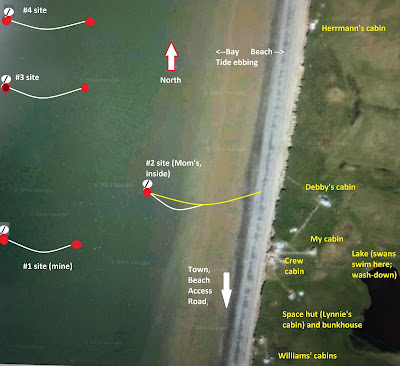
Here is an aerial view, showing the cabins up on the bluff situated in the green tundra, and the nets fishing in front of the cabins. This shows only
our nets. When we're fishing, we would see the Williams' four sites to the south of us, the McClain's site inside our #1, the Hakkenen's net outside our #2 and other neighbors north of #2 and inside #3 and #4. There are nets all along the beach. You can tell the tide is going out because the nets are belly-ing toward the Bering Sea. When the tide comes in, the water pushes the nets in the other direction.
At the top of the cliff (reached by climbing the stairs that Jean and I pulled down), Matt will probably notice first the crew cabin. When a friend of Alex's came up one season, the first thing he said was, "This is the ghetto-est place I've ever seen. Cool." I think of it as Baltic Ave in Monopoly.

Here is the crew cabin from the side in a shot that also shows the Space Hut and the bunkhouse/warehouse. Both are still boarded up and as the crew arrives, they will open the cabins and I hope, take careful note of what it means to prepare the cabins for the winter. These buildings also show up in the aerial view with the nets. My parents built the crew cabin in 1961. As the cliff has eroded, we've had to pull it back a couple of times. The warehouse was built at the same time, but it burned down in 2009, along with Harry's cabin, built in the early 80s. No one was hurt. The crew cabin is the hub of the camp. Lynnie built the Space Hut (though it wasn't the Space Hut until we reinforced it with flashing when we couldn't find any tin) and the bunkhouse a couple hundred feet off to the south.

My cabin is straight back or a little to the north, about the same distance from the cliff as Lynnie's. David's dad did a wonderful job building it in 1982 and I remain cozy in it to this day, (along with a small army of mice or lemmings).
The last cabin on the tour is Debby's. She and Darrell built it... in 1980? Quite a bit off to the north.
Debby had no sense of distance and did not intend to have a cabin about twice as big as everyone else's. But she ended up with a cabin that measured 20'X 30' (built on pallets in a swamp). The crew cabin was originally 20' X 24' and housed two adults and six kids. Lynnie's cabin was 16' X 20'. They later added an 8' x 20' mud room to the front of the cabin. Mine is a compact 12' X 20', with an added 8' X 12' mud room.


No comments:
Post a Comment